


Blanchland and the Upper Derwent
The Derwent Valley is rich in heritage and is blessed with stunning woodland gorges where wildlife is abundant. Venture into its hidden depths you won't be disappointed!
Discover more in Blanchland and the Upper Derwent
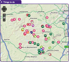
with the interactive map
The small village of Blanchland is perhaps the most attractive settlement in the whole of the North Pennines. Built from the remains of a 12th century abbey the village and the surrounding countryside are well worth a visit. Nearby is Derwent Reservoir which is the second largest reservoir in Northumberland. The reservoir is a popular place to fish for trout. You'll also find a picnic area, bird hides and an easy access path. To discover what else this area has to offer click on the map and start exploring!
The River Derwent runs alongside this small picnic area. The river used to be the boundary between County Durham and Northumberland. Hundreds of years ago the river changed its course but the boundary stayed the same and this is why the picnic site, although north of the river, belongs to Durham County Council. The sound of the flowing water is very peaceful and this is a nice place to stop and have a picnic. While sitting, look out for dippers and kingfishers by the water and buzzards flying overhead. Baybridge is an ideal starting point for local walks. Within easy reach are moorland walks, woodland walks through places such as Deborah Wood and Gibraltar, wonderful riverside walks to Derwent Reservoir and an easy access route to the historic village of Blanchland.
Location:
Baybridge is located near the B6306 near Blanchland. From Blanchland head west for 0.5 mile. The site is signposted from the road. The nearest postcode for GPS navigation is DH8 9UB,
Access:
Car parking
Recreation opportunity:
Bird watching, Nature watching, Picnicking, Walking
Interests:
Rivers
External link:

Beamish Museum is a living and working open air museum that shows what life was like in the Geordian, Edwardian and Victorian eras. Beamish stands in 300 acres of beautiful County Durham countryside. Within our site you will find Pockerley Old Hall, The Town, Rowley Station, The Fairground, Home Farm and The Pit Village. With so many things to see, Beamish is a wonderful day out for people of all ages.
Location:
Beamish Museum, Beamish, County Durham, DH9 0RG.
Access:
Car parking, Disabled, Pushchair
Accessible toilets, Cafe, Pub, Shop, Toilets
Recreation opportunity:
Culture
External link:

The small village of Blanchland, with its honey-coloured cottages, is perhaps the most attractive settlement in the North Pennines. Blanchland means 'white lands' - almost certainly a reference to the white habits (cloaks) of the Premonstratesian monks of the Abbey. The village has a tea room, shop, pub, childrens' playground and easy access walks.
Location:
Blanchland in the Upper Derwent Valley (NY966504).
Access:
Car parking
Cafe, Playground, Pub, Shop, Toilets
Recreation opportunity:
Culture, Nature watching, Picnicking, Walking
Interests:
Built heritage, Rivers, Wildlife
External link:

This 30km grand tour of Derwent Reservoir in the Upper Derwent Valley is a delight to ride. Note that this electric bike route was originally devised in 2015. It is still valid but some of the information (e.g. hire/charge points) may have changed.
Location:
Starts and finishes in Blanchland in the Upper Derwent Valley (NY965503 / DH8 9SP)
Distance:
30 km
Access:
Car parking, Public transport
Cafe, Playground, Pub, Shop, Toilets
Recreation opportunity:
Cycling
Interests:
Panoramic views
External link:
North Pennines Electric Bike Network

The landscape around Blanchland has been over 300 million years in the making. From tropical seas and deltas to glaciers, minerals and miners – all have played their part in shaping this beautiful landscape. This 6km circular walk will introduce you to some of the special features of the landscape around Blanchland. By spotting clues in the moors, fields and buildings you’ll find out how to ‘read’ the landscape and discover more about its fascinating past. The sections opposite give some background information about how the local rocks and minerals formed, and tell you a bit about the area’s mining heritage.
Location:
Starting from Blanchland car park (NY964504 / DH8 9TA - nearest).
Distance:
6 km
Access:
Car parking, Public transport
Accessible toilets, Cafe, Playground, Pub, Shop, Toilets
Recreation opportunity:
Nature watching, Walking
Interests:
Built heritage, Geology, Industrial heritage, Moorlands, Rivers, Wildlife
External link:

This 21km circular horse riding route is 70% off-road and enjoys 1,027m of ascent. It starts at Baybridge, close to the village of Blanchland. You’ll follow the Carriers’ Way across Bulbeck Common, alive with the evocative calls of wading birds in the spring and early summer.
Location:
Starts and finishes in the Baybridge car park (NY957499 / DH8 9UB - nearest).
Distance:
21 km
Access:
Car parking
Recreation opportunity:
Horse riding
Interests:
Industrial heritage, Panoramic views
External link:
Packhorse Trails for Horse Riders

This 21km circular mountain biking route is 70% off-road and enjoys 1,027m of ascent. It starts at Baybridge, close to the village of Blanchland. You’ll follow the Carriers’ Way across Bulbeck Common, alive with the evocative calls of wading birds in the spring and early summer.
Location:
Starts and finishes in the Baybridge car park (NY957499 / DH8 9UB - nearest).
Distance:
21 km
Access:
Car parking
Recreation opportunity:
Cycling
Interests:
Industrial heritage, Panoramic views
External link:
Packhorse Trails for Mountain Bikers

This short walk takes you from the village of Blanchland along the River Derwent to the hamlet of Baybridge and back. You'll walk back to Blanchland through lovely mixed woodlands and perhaps get a glimpse of the elusive Water Vole - if you're really, really lucky! The path may be wet and muddy in places and you will come across exposed tree roots.
Location:
Staring from Blanchland car park (NY964505).
Distance:
2 km
Access:
Car parking, Public transport
Accessible toilets, Cafe, Playground, Pub, Toilets
Recreation opportunity:
Bird watching, Nature watching, Walking
Interests:
Built heritage, Rivers, Wildlife, Woods
External link:

This short walk from the attractive and historic village of Blanchland combines both woodland and river habitats. Birds such as coal tit, goldcrest and dipper are active throughout the year. During the breeding season, more elusive species such as the pied flycatcher and spotted flycatcher can also be seen. Blanchland is sited within the remains of a monastery founded by Premonstratensian Monks in the 12th century. The Lord Crewe Arms hotel was originally built as the Abbot’s lodge, guest house and kitchens of the Abbey.
Location:
Starting from the car park in Blanchland (NY964505).
Distance:
3 km
Access:
Car parking
Accessible toilets, Cafe, Playground, Pub, Toilets
Recreation opportunity:
Bird watching, Nature watching, Walking
Interests:
Built heritage, Rivers, Wildlife, Woods
External link:
Birdwalks North Pennines

Even in the depths of winter the heather moorland at Burnhope Head is home to large numbers of red grouse. Seeming to catapult from the heather in display whilst giving their loud “get back, get back” call, red grouse are a dramatic sight. During spring and summer their numbers are swelled by a multitude of breeding waders and the moorland seems to burst with life. With sweeping views all around, this is always an impressive walk.
Location:
Starting from the large lay-by near Dead Friars Stone (NY973453).
Distance:
5 km
Access:
Car parking
Recreation opportunity:
Bird watching, Nature watching, Walking
Interests:
Industrial heritage, Moorlands, Panoramic views, Reservoirs, Wildlife
External link:
Birdwalks North Pennines

The upland oak woodland of the Derwent Gorge is a dramatic relic of the once extensive forests of the North Pennines. Now a National Nature Reserve managed by Natural England, this woodland contains many interesting and unusual plants such as sweet woodruff, enchanters’ nightshade and wood bitter-cress as well as a great range of resident and migratory birds. Views across the woodland canopy from the gorge sides are impressive and are excellent for bird watching. The walk begins on the edge of the wood in an area of arable farmland, offering opportunities for you to see both farmland and woodland birds.
Location:
Starting from the grassy parking area at the crossroad between Wallish Walls and Crooked Oak (NZ057500).
Distance:
2 km
Access:
Car parking
Recreation opportunity:
Bird watching, Nature watching, Walking
Interests:
Industrial heritage, Panoramic views, Rivers, Wildlife, Woods
External link:
Birdwalks North Pennines

Derwent Reservoir is Northumbrian Waters most popular fishery, with anglers liking the combination of lots of bank space and the chance to catch specimen trout weighing up to 20 lbs. Throughout the season a number of tagged fish will be stocked with special prizes awarded to those anglers lucky enough to catch them. In addition, there is a designated pegged area for coarse anglers who can expect to catch some quality roach. Derwent is suitable for disabled anglers and visitors. On site they have an excellent shop stocked with everything you need for a day's fishing including rods, reels, tackle, accessories, clothing, worms, bait, ice creams and refreshments including cold drinks. Environment Agency rod licences are also on sale at this fishery. For those not fishing, there are several picnicking and play areas, plus spectacular walks along the north and south shores and across the dam. A wheelchair accessible trail runs from the south end of the dam along to Pow Hill Country Park and from the north shore of the dam wall to Millshield picnic site. Permits can be purchased online through the Fishpal website (www.fishpal.com/NorthumbrianWater).
Location:
Located just off the A68 and four miles west of Castleside, turn south at the Manor House pub and follow the road into the valley
Access:
Car parking, Disabled, Pushchair
Accessible toilets, Shop, Toilets
Recreation opportunity:
Fishing

Derwent Reservoir is within the North Pennines AONB and, after Kielder, is the second largest reservoir in the region. There is a multi-user path from Pow Hill Country Park (south shore) to the dam at the eastern end of the reservoir and then round the north shore to Millshield Picnic Area. You can find out more about the reservoir, its wildlife and its history as you go, on foot or by bike. Cyclists can make a longer circular route around the reservoir by combining the shore path with local roads.
Location:
Derwent Reservoir is in the north-eastern part of the North Pennines AONB, between Blanchland and Edmundbyers - the south shore is in County Durham and the north shore is in Northumberland. Start from Pow Hill Country Park (NZ011517 / DH8 9NU - nearest) or Millshield Picnic Area (NZ013532 / DH8 9PT - nearest).
Distance:
3 km
Access:
Car parking, Disabled, Public transport, Pushchair
Shop, Toilets
Recreation opportunity:
Bird watching, Cycling, Horse riding, Nature watching, Picnicking, Running, Stargazing, Walking
Interests:
Reservoirs, Wildlife
External link:

Welcome to Derwent Reservoir and Pow Hill Country Park! This leaflet is one of a number of ways in which you can find out about the wildlife and history of Derwent Reservoir and Pow Hill Country Park. The heathland around the reservoir is a haven for reptiles like Adders, Slow Worms and Common Lizards. The reservoir is also important to many species of birds which use it as a migratory stop over and breeding site.
Location:
Routes starting from either Derwent Reservoir car park or Pow Hill Country Park car park.
Distance:
2 km
Access:
Car parking, Disabled, Pushchair
Accessible toilets, Cafe, Pub, Toilets
Recreation opportunity:
Bird watching, Nature watching, Walking
Interests:
Industrial heritage, Panoramic views, Reservoirs, Wildlife
External link:
Blanchland and the Upper Derwent

Derwent Reservoir can be an interesting place to watch birds at any time of year. Wildfowl such as greylag goose, mallard, teal and tufted duck may be seen year-round, their numbers being swelled during autumn and winter by wigeon, pochard and goldeneye. Large flocks of gulls also congregate on the reservoir during the winter, most notably black headed, common and herring gull. Other species of interest include grey heron, goosander, cormorant and great crested grebe.
Location:
Multiple viewing points around the reservoir.
Access:
Car parking, Disabled, Public transport, Pushchair
Accessible toilets, Pub, Toilets
Recreation opportunity:
Bird watching, Nature watching, Walking
Interests:
Industrial heritage, Panoramic views, Reservoirs, Wildlife, Woods
External link:
Birdwalks North Pennines

Located at Derwent reservoir, the Derwent Sailing Club has excellent facilities including a two storey club house with bar and restaurant. The club is a RYA training centre.
Location:
Derwent Reservoir
Access:
Car parking
Cafe, Pub, Toilets
Recreation opportunity:
Sailing
Interests:
Reservoirs
External link:
Derwent Sailing Club

A three mile walk of contrasts between urban streets and rural woods and views, exploring traces of the lost lead industry and other remains in the Blaydon area. Developed as part of the Dukesfield Smelters and Carriers Project (www.dukesfield.org.uk).
Location:
Start either from Blaydon Railway Station or the Blaydon Shopping Centre car park.
Distance:
5 km
Access:
Car parking, Public transport
Cafe, Shop
Recreation opportunity:
Walking
Interests:
Industrial heritage
External link:

Perhaps the most spectacular medieval ruin in the AONB, Muggleswick Grange was built during the mid-1200s for the Prior of Durham and originally lay in the grounds of an enclosed park. Muggleswick is of national importance because standing remains of monastic granges from this time are very unusual. A grange was a farm owned and run by the monastic community to provide food and materials for the parent monastic house and to sell surpluses for profit. A 1464 document shows that at Muggleswick there was a hall, chapel, grange and a dairy, and a large stock of oxen, cattle, calves, sheep, pigs and lambs. The Grange may originally have consisted of several buildings arranged around a courtyard, but today much of the site is occupied by later buildings, themselves perhaps dating back to the 17th Century and built with stone plundered from the Grange ruins. The imposing east gable includes a large lancet window, later blocked and modified to function as a chimney.
Location:
In Muggleswick, between Edmundbyers and Castleside.
Access:
Recreation opportunity:
Culture

This leaflet is one of a series designed to help you discover the treasures of Blanchland - both natural and man-made. This attractive walk takes you from Blanchland, along the River Derwent, up on to open moorland. The moorland is exposed and can experience harsh weather. The wild landscape surrounding Blanchland bustles with evidence of people, from Mesolithic hunters to lead miners and modern land managers. Everywhere you look you see the imprint of our ancestors. Many landscape scars have been hidden by nature and it is hard to believe that in the not-so-distant past this quiet landscape was once home to major industry.
Location:
The walk starts from Blanchland car park (NY964505)
Distance:
14 km
Access:
Car parking, Public transport
Accessible toilets, Cafe, Playground, Pub, Toilets
Recreation opportunity:
Bird watching, Nature watching, Walking
Interests:
Built heritage, Geology, Industrial heritage, Moorlands, Panoramic views, Wildlife
External link:
Blanchland and the Upper Derwent

This is a varied walk that begins with a climb up from the village of Blanchland. The walk passes through woodland and pasture with magnificent views of the Derwent Valley and Edmundbyers Common, finally dropping down to the river and returning to the village.
Location:
Staring from Blanchland car park.
Distance:
6 km
Access:
Car parking, Public transport
Accessible toilets, Cafe, Playground, Pub, Toilets
Recreation opportunity:
Bird watching, Nature watching, Walking
Interests:
Built heritage, Moorlands, Panoramic views, Reservoirs, Rivers, Wildlife, Woods

Pow Hill is a country park owned by Durham County Council and was one of the first five Dark Sky Discovery Sites to be designated in the North Pennines. Recognised for the quality of its dark night skies, set away from the nearby small settlements of Blanchland and Edmundbyers, this is a brilliant spot for astronomers to stargaze. Its position on the edge of Derwent Reservoir offers a large, uninterrupted view of the northern sky. Under a clear winter nights sky, the main stellar constellations can be seen and on good nights, the Milky Way can also be seen with the naked eye. Good quality surface in the car park and an easy access trail route (on the shore of the reservoir) offers the opportunities for disabled people to stargaze.
Location:
Located off the B6306 Blanchland road on the south shore of Derwent Reservoir - 1 mile north of Edmundbyers, signposted from the road.
Access:
Car parking, Disabled, Pushchair
Recreation opportunity:
Stargazing
Interests:
Panoramic views, Reservoirs
External link:
Dark Sky Discovery Sites

Shildon Engine House was built around 1805 to house a Cornish pumping engine, which kept the network of lead mines operating underneath from flooding. Towards the end of its industrial life in the 1840s, an enormous steam engine was installed in a final attempt to keep the mines dry enough to work. Following decommissioning, the engine house was converted to a series of flats for mining families. It was finally abandoned around 100 years ago and has been derelict ever since. The Engine House is a dramatic reminder of a once thriving lead mining community of 170 people. The population declined after the mid-1800s when cheaper lead began to be imported from abroad, and young Shildon families emigrated to the gold-mining areas of Australia and America. Facilities are available off site in Blanchland.
Location:
On the outskirts of Blanchland.
Access:
Car parking
Accessible toilets, Cafe, Pub, Toilets
Recreation opportunity:
Culture
This 10km walk between the stations of Riding Mill and Corbridge is mainly along fields and woodland paths with some short sections on quiet country roads. There is a steep climb out of Riding Mill. The woodlands above Riding Mill and Corbridge are good places to see birds like Redstart, Pied Flycatcher, Wood warblers and Woodpeckers. Note Corbridge town centre is over the bridge across the River Tyne. Corbridge has a full range of shops and services while Riding Mill has a small range of services.
Location:
Starting from Riding Mill station.
Distance:
10 km
Access:
Car parking, Public transport
Accessible toilets, Cafe, Pub, Shop, Toilets
Recreation opportunity:
Bird watching, Nature watching, Walking
Interests:
Wildlife, Woods
External link:
http://www.nationaltrail.co.uk/hadrianswall/downloads.asp?PageId=89
This 9km walk between the stations of Corbridge and Hexham is along riverside and woodland paths and tracks, with some road walking mainly in Hexham. The walk crosses the railway line and is not boarded. Please take care! Note Corbridge town centre is over the bridge across the River Tyne.
Location:
Starting from Corbridge train station.
Distance:
9 km
Access:
Public transport
Accessible toilets, Cafe, Playground, Pub, Shop, Toilets
Recreation opportunity:
Walking
Interests:
Built heritage, Rivers, Woods
External link:
http://www.nationaltrail.co.uk/hadrianswall/downloads.asp?PageId=89
This 17km walk between the stations of Hexham and Haydon Bridge includes field and woodland paths with some sections on minor roads. This is a long walk with some steep climbs. Hexham has a full range of shops and services while Haydon Bridge has some shops, a post office and pubs.
Location:
Starting from Hexham train station.
Distance:
17 km
Access:
Car parking, Public transport
Accessible toilets, Cafe, Playground, Pub, Shop, Toilets
Recreation opportunity:
Walking
Interests:
Built heritage, Rivers, Wildlife, Woods
External link:
http://www.nationaltrail.co.uk/hadrianswall/downloads.asp?PageId=89

This route (walk, cycle, horse ride) follows the Lanchester Valley and Waskerley Way Railway Paths, climbing from the pleasant pastoral landscape near Durham to the rugged heather covered Stanhope Moor. The route is excellent for walkers, cyclists and riders, with its easy to follow, car-free sections. Wonderful wildlife, fascinating history and spectacular views are all on offer on this gem of a trail. You can approach this linear route starting in either direction and can tailor the length to suit your own requirements. In this leaflet we have made suggestions for three sections of varying lengths along the route. From Durham to Stanhope, this route starts at Broompark, near Neville’s Cross in Durham and follows mainly dedicated paths along old railway tracks for 22 miles to Parkhead above Stanhope, in Weardale. There are a number of great places along the way to stop for a bite to eat and a brew. Lanchester and Consett are also good places to join the route and it can be done in shorter sections. This route is accessible to all users.
Location:
Starting from the Durham County Council car park at Broompark (NZ250415), Durham.
Distance:
34 km
Access:
Car parking
Recreation opportunity:
Cycling, Food trails, Horse riding, Running, Walking
Interests:
Panoramic views
External link:

Gordon Lamb is a professional artist with a distinctive style, who specialises in painting with watercolours. Keep your eye on his website for information about upcoming classes. If you are visiting the area or if you simply want to have a one-off taster, a single session with Gordon can be tailored for beginners or the more advanced. Gordon also runs workshops for art groups, retreat groups or business groups seeking a creative professional development session at your chosen location.
Location:
Various
Access:
Recreation opportunity:
Arts and craft, Culture
External link:
Watercolour painting with Gordon Lamb
