


Teesdale
The sweep of the moors and crags of upper Teesdale have an unrivalled drama which people come back to savour time and time again.
Discover more in Teesdale
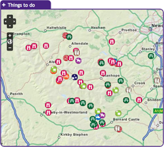
with the interactive map
Teesdale is a big draw for botanists with some of England’s rarest upland plants found here. Heritage fans are spoiled for choice with its impressive medieval castles and the exquisite Bowes Museum which is home to a wonderful collection of fine and decorative art. Some of the most impressive sections of the Pennine Way National Trail are found in Teesdale and there are numerous excellent circular walks. Bowlees Visitor Centre is a great place to start your discovery, with access to the impressive waterfalls of High and Low Force. To discover what else Teesdale has to offer click on the map and start exploring!

Ark on the edge is an animal rescue centre and sanctuary and has a fully equipped wildlife education centre and a mile-long nature trail. The centre offers courses in animal care and group visits are welcome. It is open to the public to visit, see the animals, walk the nature trail, or you can do a spot of pond dipping. Ark on the Edge welcomes disabled visitors, call for details (01833 630505).
Location:
Woolley Hill Farm, Woodland, Co. Durham, DL13 5RX (NZ044249)
Distance:
2 km
Area:
Access:
Car parking, Disabled, Pushchair
Accessible toilets, Toilets
Recreation opportunity:
Bird watching, Nature watching, Outdoor education
Interests:
Wildlife
External link:

Designated as a Dark Sky Discovery Site, Balderhead Reservoir has been recognised for the quality of the night time skies. This is a great place for professional and amateur astronomers to stargaze in the North Pennines AONB. It is also one of best wild brown trout fisheries in the country.
Location:
From Barnard Castle follow the B6277 to Romaldkirk and then follow the Balderhead road via Hunderthwaite. The reservoir is signposted at the entrance to the car park approximately 4.5 miles along this road. Car park on the NE side of the reservoir.
Area:
Access:
Car parking, Pushchair
Recreation opportunity:
Stargazing
Interests:
Panoramic views, Reservoirs
External link:

This circular 18km (60% off-road) horse riding trail has 370m of ascent and starts from the south side of Hury Reservoir. It initially follows the banks of Hury and Blackton Reservoirs in remote Baldersdale, before striking off over the moors on the Pennine Way.
Location:
Starts and finishes from the Northumbrian Water car park on the south side of Hury Reservoir (NY966192 / DL12 9UP - nearest).
Distance:
18 km
Area:
Access:
Car parking
Recreation opportunity:
Horse riding
Interests:
Industrial heritage, Panoramic views
External link:

This circular 18km (60% off-road) mountain biking trail has 370m of ascent and starts from the south side of Hury Reservoir. It initially follows the banks of Hury and Blackton Reservoirs in remote Baldersdale, before striking off over the moors on the Pennine Way.
Location:
Starts and finishes from the Northumbrian Water car park on the south side of Hury Reservoir (NY966192 / DL12 9UP - nearest).
Area:
Access:
Car parking
Recreation opportunity:
Cycling
Interests:
Industrial heritage, Panoramic views
External link:

This short walk in Baldersdale visits some of the most spectacular hay meadows in the North Pennines. It also passes close to Hury Reservoir, a popular site for over-wintering wildfowl such as mallard, teal, tufted duck and goosander. The best time to see the flowers is between April and August. Meadows are great for water voles as they favour stream sides with a wide range of flowering plants. The North Pennines is one of their last strongholds
Location:
Starting from the small car park at Fiddler House (NY971189).
Distance:
6 km
Area:
Access:
Car parking
Toilets
Recreation opportunity:
Bird watching, Nature watching, Walking
Interests:
Hay meadows, Reservoirs, Wildlife
External link:

This route (walk, cycle, horse ride) takes you along the old railway line that serviced the stone quarrying industry in Teesdale. The route start is close to Barnard Castle, although you can pick it up at a number of points along to way - splitting it into shorter sections. This guide has been written as a linear route but if you choose to walk it is possible to make shorter circular walks connecting up with other footpaths including the Teesdale Way. The majority of the path is along the old railway line. The section of the railway line from Barnard Castle to Middleton-in-Teesdale was built by the Tees Valley Railway company during 1868 with stops at Cotherstone, Mickleton and Romaldkirk. There are two major engineering features on the line the Lunedale and Baldersdale Viaducts, you will pass over both these on this route. The decline of this section of railway started in the late 1950s and the line was earmarked for closure as part of the Beeching cuts with the last train running in April 1965.
Location:
Starting from Deepdale aqueduct layby on the B6277 outside Barnard Castle.
Distance:
16 km
Area:
Access:
Car parking, Public transport
Accessible toilets, Cafe, Playground, Pub, Shop, Toilets
Recreation opportunity:
Cycling, Food trails, Horse riding, Running, Walking
External link:

The meadows, pastures and allotments of Baldersdale support large numbers of breeding waders which make an impressive sight during the spring and summer months. Like all areas of open water in the North Pennines, Blackton Reservoir also provides a refuge for wildfowl during the harsh winter months. This area is therefore worth a visit at any time of year.
Location:
Starting from the small car park at the road end (NY935176).
Distance:
6 km
Area:
Access:
Car parking
Recreation opportunity:
Bird watching, Nature watching, Walking
Interests:
Hay meadows, Industrial heritage, Moorlands, Panoramic views, Reservoirs, Rivers, Wildlife
External link:

Bowlees picnic area is found is located in a beautiful part of Upper Teesdale. There are four small waterfalls and a riverside footpath leading to Summerhill Force and Gibson’s Cave; Gibson was a 16th century outlaw who lived behind the waterfall to stay hidden from the law. There are plenty of places to sit in quiet contemplation surrounded by the sound of cascading water. Look for the white breast of the dipper bobbing in and out of the water searching for food or the buzzard soaring above your head. The old limestone quarry contains many limestone-loving wildflowers, including seven species of orchids, knapweed and wild thyme. These plants attract butterflies and other insects, which are prey for magnificent dragonflies.
Location:
The picnic area is located in the car park behind Bowlees Visitor Centre off the B 6277.
Area:
Access:
Car parking, Disabled, Public transport, Pushchair
Accessible toilets, Cafe, Toilets
Recreation opportunity:
Bird watching, Picnicking, Walking

Bowlees Visitor Centre, run by the North Pennines AONB Partnership, is a fantastic base for exploring Upper Teesdale, with footpath links to Low Force, High Force, Newbiggin and the Pennine Way. The Centre provides information and displays on the geology and landscape, wildlife and people of Upper Teesdale and the wider North Pennines. You'll find a delicious range of food and drinks and our shop stocks nature inspired gifts and books. You'll find a range of special events are running at the Centre throughout the year. You can also hire the venue for family get-togethers, parties and meetings. We have a range of outdoor cooking facilities which can be pre-booked. The Centre is dog-friendly and you'll find free Wi-Fi access, an iGlass (24-hour information touch screen) and an electric car-charging point. Follow the Richard Watson Trail from the Centre - a 2¾-mile circular route exploring the life and times of Richard Watson, Victorian lead miner and poet. The most popular walk is probably the High Force-Low Force Round. The Centre is also an official Dark Sky Discovery Site.
Location:
Newbiggin, Bowlees, Middleton-in-Teesdale, Co. Durham, DL12 0XE (grid ref - NY906281). 01833 622145.
Area:
Access:
Car parking, Cycle parking, Disabled, Public transport, Pushchair
Accessible toilets, Cafe, Shop, Toilets
Recreation opportunity:
Arts and craft, Bird watching, Canoeing and kayaking, Culture, Cycling, Information points, Nature watching, Outdoor education, Picnicking, Running, Walking
Interests:
Geology, Hay meadows, Industrial heritage, Rivers, Wildlife, Woods
External link:

Designated as a Dark Sky Discovery Site, Bowlees Visitor Centre has been recognised for the quality of its dark night skies. This is a great place for professional and amateur astronomers to stargaze.
Location:
Newbiggin, Bowlees, Middleton-in-Teesdale, Co. Durham, DL12 0XF. 01833 622145.
Area:
Access:
Car parking, Cycle parking, Disabled, Public transport, Pushchair
Accessible toilets, Cafe, Shop, Toilets
Recreation opportunity:
Stargazing
External link:

This 27km road route starts at Bowlees Visitor Centre and explores Upper Teesdale. Note that this electric bike route was originally devised in 2015. It is still valid but some of the information (e.g. hire/charge points) may have changed.
Location:
Starts and finishes at Bowlees Visitor Centre in Upper Teesdale (NY906282 / DL12 0XE)
Distance:
27 km
Area:
Access:
Car parking, Cycle parking
Accessible toilets, Cafe, Shop, Toilets
Recreation opportunity:
Cycling
Interests:
Panoramic views
External link:

This fantastic walk starts in Middleton-in-Teesdale, explores the Hudeshope Valley and then makes its way over the tops to Forest-in-Teesdale. The return leg follows the Pennine Way - past High Force and Low Force waterfalls. Part of the Gold Challenge developed by the Upper Teesdale Tourism Network (UTTN). The Challenge Walks (www.teesdalechallengewalks.net) are a series of walks produced by the UTTN to help visitors and local people to explore this spectacular part of the North Pennines Area of Outstanding Natural Beauty and UNESCO Global Geopark. For detailed walk directions click the link below.
Location:
Starts from the Market Place in Middleton-in-Teesdale.
Distance:
26 km
Area:
Access:
Car parking, Public transport
Accessible toilets, Cafe, Playground, Pub, Shop, Toilets
Recreation opportunity:
Walking
External link:

Grand circuit of Teesdale starting from Middleton-in-Teesdale - taking in Bowlees Visitor Centre and Low Force. Part of the Silver Challenge developed by the Upper Teesdale Tourism Network (UTTN). The Challenge Walks (www.teesdalechallengewalks.net) are a series of walks produced by the UTTN to help visitors and local people to explore this spectacular part of the North Pennines Area of Outstanding Natural Beauty and UNESCO Global Geopark. For detailed walk directions click the link below.
Location:
Start from the Tourist Information Centre in the centre of Middleton-in-Teesdale.
Distance:
17 km
Area:
Access:
Car parking, Public transport
Accessible toilets, Cafe, Playground, Pub, Shop, Toilets
Recreation opportunity:
Walking
External link:

The trail will introduce many of the rocks which make the Teesdale landscape so special and which make the dale a haven for rare and interesting plants. This trail is within Moor House-Upper Teesdale National Nature Reserve (NNR), an internationally important place for wildlife and earth heritage. The NNR is managed by Natural England in partnership with Raby and Strathmore Estates and local farmers. Do examine the rocks, minerals and plants you will see along the way but please do not collect them: leave them for others to enjoy.
Location:
Starting from Wheelhead Sike car park at Cow Green.
Distance:
8 km
Area:
Access:
Car parking
Recreation opportunity:
Nature watching, Walking
Interests:
Geology, Industrial heritage, Moorlands, Panoramic views, Reservoirs, Rivers, Wildlife
External link:

Designated as a Dark Sky Discovery Site, Cow Green Reservoir has been recognised for the fantastic quality of its night time skies. This is a great place for professional and amateur astronomers to stargaze in the North Pennines AONB. Cow Green Reservoir is also one of best wild brown trout fisheries in the country.
Location:
From Middleton-in-Teesdale head up the dale to Langdon Beck on the B6277. Turn left onto a small road (signposted Cow Green Reservoir) and continue along here for approximately 2 miles to a car park.
Area:
Access:
Car parking, Pushchair
Recreation opportunity:
Stargazing
Interests:
Panoramic views, Reservoirs
External link:

This long walk in Teesdale starts in Middleton-in-Teesdale and explores the Pennine Way, via High Force, over Cronkley Scar and back to Middleton. Part of the Gold Challenge developed by the Upper Teesdale Tourism Network (UTTN). The Challenge Walks (www.teesdalechallengewalks.net) are a series of walks produced by the UTTN to help visitors and local people to explore this spectacular part of the North Pennines Area of Outstanding Natural Beauty and UNESCO Global Geopark. For detailed walk directions click the link below.
Location:
Starts from the Market Place in the centre of Middleton-in-Teesdale.
Distance:
30 km
Area:
Access:
Car parking, Public transport
Accessible toilets, Cafe, Playground, Pub, Shop, Toilets
Recreation opportunity:
Walking
External link:

Fantastic walk starting in Middleton-in-Teesdale crossing the wilds of Crossthwaite Common. Part of the Silver Challenge developed by the Upper Teesdale Tourism Network (UTTN). The Challenge Walks (www.teesdalechallengewalks.net) are a series of walks produced by the UTTN to help visitors and local people to explore this spectacular part of the North Pennines Area of Outstanding Natural Beauty and UNESCO Global Geopark. For detailed walk directions click the link below.
Location:
Start from the Market Place in the centre of Middleton-in-Teesdale.
Distance:
16 km
Area:
Access:
Car parking, Public transport
Accessible toilets, Cafe, Playground, Pub, Shop, Toilets
Recreation opportunity:
Walking
Interests:
Panoramic views
External link:

Mid Teesdale sits between the two market towns of Middleton and Barnard Castle. The River Tees meanders its way through this beautiful dale, which is surrounded by the high moorland of the North Pennines. The area has a wealth of history and nature waiting to be explored, with attractive villages from which to base your visit. This publication will help you to discover the area and its main settlements at a leisurely pace, with six routes for walking, cycling and horse riding.
Location:
Routes starting from either Mickleton (NY967233 / DL12 0JN - nearest) and Middleton-in-Teesdale (NY947254 / DL12 0SH).
Area:
Access:
Car parking, Cycle parking, Public transport
Accessible toilets, Cafe, Playground, Pub, Toilets
Recreation opportunity:
Cycling, Horse riding, Walking
External link:

This woodland came into Durham County Council ownership when the sand and gravel quarry closed in the mid 1960s. Since that time the trees have seeded into the quarry and we now have mixed broadleaved woodland. Eggleston Burn runs along the western edge beside the old sand quarry. In the summer sand martins nest in the cliff face and can be seen from the bottom path. Other birds to watch out for are dippers and birds of prey such as red kite and buzzard. Deer and badger occasionally stray through the wood and many rabbits burrow through the soft sandy soil. Every now and then an otter is sighted on its journey along the river. There are fantastic views over Teesdale and Mickle Fell, which, standing at 788m, is the highest hill in County Durham.
Location:
1 mile west of Eggleston on the B6282 between Eggleston and Middleton-in-Teesdale. The entrance is next to Egglesburn bridge. Nearest postcode for GPS navigation is DL12 0BD. There is limited parking at the entrance.
Area:
Access:
Car parking, Public transport
Recreation opportunity:
Bird watching, Nature watching, Walking
Interests:
Rivers, Wildlife, Woods
External link:

This cracking route takes in parts of the Teesdale Way and Tees Railway Path. Part of the Silver Challenge developed by the Upper Teesdale Tourism Network (UTTN). The Challenge Walks (www.teesdalechallengewalks.net) are a series of walks produced by the UTTN to help visitors and local people to explore this spectacular part of the North Pennines Area of Outstanding Natural Beauty and UNESCO Global Geopark. For detailed walk directions click the link below.
Location:
Start from the fountain in the centre of Middleton-in-Teesdale.
Distance:
15 km
Area:
Access:
Car parking, Public transport
Accessible toilets, Cafe, Playground, Pub, Shop, Toilets
Recreation opportunity:
Walking
Interests:
Rivers
External link:

Grassholme is firmly established as one of the top any method fisheries in the country, lying in the picturesque rolling pasture land of upper Teesdale. With four miles of bank space and many inlets and bays it offers a great variety of fishing. Grassholme also enjoys the luxury of its own local fish farm. Grassholme is suitable for disabled anglers and visitors. On site Northumbrian Water have provided an excellent lodge shop stocked with everything you need for a day’s fishing including rods, reels, tackle, accessories, clothing, worms, bait, ice creams and refreshments including hot and cold drinks. Environment Agency rod licences are also on sale at the fishery. There is a circular footpath around the lake providing magnificent views across the water and a pleasant picnicking area next to the visitor centre for you to relax at.
Location:
Take the B6277 from Barnard Castle towards Mickleton. Turn off at the western end of the village, sign posted Grassholme Reservoir. The trout fishery is roughly a mile up the road on the right
Area:
Access:
Car parking, Disabled
Accessible toilets, Shop, Toilets
Recreation opportunity:
Fishing

This walk is a grand circuit of Grassholme Reservoir starting from Middleton-in-Teesdale. Part of the Silver Challenge developed by the Upper Teesdale Tourism Network (UTTN). The Challenge Walks (www.teesdalechallengewalks.net) are a series of walks produced by the UTTN to help visitors and local people to explore this spectacular part of the North Pennines Area of Outstanding Natural Beauty and UNESCO Global Geopark. For detailed walk directions click the link below.
Location:
Starting from the Market Place in the centre of Middleton-in-Teesdale.
Area:
Access:
Car parking, Public transport
Accessible toilets, Cafe, Playground, Pub, Shop, Toilets
Recreation opportunity:
Walking
Interests:
Reservoirs
External link:

Designated as a Dark Sky Discovery Site, Grassholme Reservoir has been recognised for the stunning quality of its night skies. This is a great place for professional and amateur astronomers to stargaze in the North Pennines AONB. Access to the reservoir for stargazing is only available during organised events (see www.northpennines.org.uk for details). Grassholme is also firmly established as one of the top 'any method fisheries' in the country.
Location:
Take the B6277 from Barnard Castle towards Mickleton. Turn off at the western end of the village, signposted Grassholme Reservoir. The main car park is roughly a mile up the road on the right.
Area:
Access:
Car parking, Disabled, Pushchair
Shop, Toilets
Recreation opportunity:
Stargazing
Interests:
Panoramic views, Reservoirs
External link:

This long circular walk from Middleton-in-Teesdale takes you up to Hamsterley Forest and back. Part of the Gold Challenge developed by the Upper Teesdale Tourism Network (UTTN). The Challenge Walks (www.teesdalechallengewalks.net) are a series of walks produced by the UTTN to help visitors and local people to explore this spectacular part of the North Pennines Area of Outstanding Natural Beauty and UNESCO Global Geopark. For detailed walk directions click the link below.
Location:
The walk starts from the fountain in the centre of Middleton-in-Teesdale.
Distance:
27 km
Area:
Access:
Car parking, Public transport
Accessible toilets, Cafe, Playground, Pub, Shop, Toilets
Recreation opportunity:
Walking
External link:

County Durham's largest forest is a mixture of woodland, meadows and forest. There are excellent walking, cycling and horse riding trails for all abilities. The forest also has a childrens' adventure playground, tea room, cycle hire, shop and downhill mountain bike course.
Location:
Hamsterley Forest (NZ091312 / DL13 3QH).
Area:
Access:
Car parking, Cycle parking, Disabled, Pushchair
Accessible toilets, Cafe, Playground, Shop, Toilets
Recreation opportunity:
Bird watching, Cycling, Horse riding, Information points, Nature watching, Picnicking, Stargazing, Walking
Interests:
Panoramic views, Wildlife, Woods
External link:

This is the most strenuous and technically challenging waymarked mountain bike trail in Hamsterley Forest. It sports steep technical climbs, smooth contouring single track and some superb rooty descents. This character stays with the trail for its entire length and boasts some great natural riding that will challenge even the best cross country bikers. It starts from the forest drive just beyond the visitor centre.
Location:
Hamsterley Forest (NZ091312 / DL13 3QH).
Distance:
11 km
Area:
Access:
Car parking, Cycle parking
Accessible toilets, Cafe, Playground, Shop, Toilets
Recreation opportunity:
Cycling
External link:

This mountain bike trail provides you with the ideal opportunity to explore Hamsterley Forest at a leisurely pace. The first stretch to Grove House is on a wide, purpose built cycle trail, before joining the Forest Drive to Blackling Hole. This stretch and the return through the forest to the Grove, is all on loose surfaced forest road. Please exercise caution when cycling on forest roads as this is shared with other users, including timber lorries. The last two miles is on the tarmac section of the Forest Drive.
Location:
Hamsterley Forest (NZ091312 / DL13 3QH).
Distance:
14 km
Area:
Access:
Car parking, Cycle parking
Accessible toilets, Cafe, Playground, Shop, Toilets
Recreation opportunity:
Cycling
External link:

Doctors Gate is a 21.8 mile circular mountain bike route, starting from Hamsterley Forest, climbing 2821ft using quiet road sections to link the off road sections. The route should be tackled clockwise - start off by going along the Grove Link. There are more road miles on this route than ideal for a mountain bike ride but the blast down the Weardale Way and the descent into the forest make up for this.
Location:
Hamsterley Forest (NZ091312 / DL13 3QH).
Distance:
35 km
Area:
Access:
Car parking, Cycle parking
Accessible toilets, Cafe, Playground, Shop, Toilets
Recreation opportunity:
Cycling
Interests:
Panoramic views
External link:

Starting in Hamsterley Forest this lollipop-shaped mountain bike route takes you across the moors to Eggleston and back. Best ridden on a dry day when there has been a dry spell beforehand!
Location:
Hamsterley Forest (NZ091312 / DL13 3QH).
Distance:
30 km
Area:
Access:
Car parking, Cycle parking
Accessible toilets, Cafe, Playground, Shop, Toilets
Recreation opportunity:
Cycling
Interests:
Panoramic views
External link:

A mountain bike trail for real adventurers who want to spend the day exploring the further reaches of Hamsterley Forest. The route follows the Blue Trail to the Grove before heading into the wider forest on a mixture of forest road and singletrack. Superb views await at the top of the forest overlooking Eggleston Moor before returning to the Grove via the Euden Beck on breathtaking stretches of singletrack.
Location:
Hamsterley Forest (NZ091312 / DL13 3QH).
Distance:
22 km
Area:
Access:
Car parking, Cycle parking
Accessible toilets, Cafe, Playground, Shop, Toilets
Recreation opportunity:
Cycling
Interests:
Panoramic views
External link:

This is a purpose built mountain bike training loop. It is designed with skill development in mind to push your mountain biking to a new level. The Loop contains a multitude of features and riding options, some built in stone to mimic natural trails and others from timber in the North Shore style. Each feature has a skills tips board containing information to help perfect your technique. When you reach the bottom you can either exit The Loop or go back to the top via the climb trail. The training loop is aimed at anybody confident at riding Blue Grade trail or above, but beware it contains features of all grades from Blue to Black. The trail is not suitable for occasional/family cyclists and all riders are advised to wear suitable personal protective equipment.
Location:
Hamsterley Forest (NZ091312 / DL13 3QH).
Distance:
2 km
Area:
Access:
Car parking, Cycle parking
Accessible toilets, Cafe, Playground, Shop, Toilets
Recreation opportunity:
Cycling
External link:

The Hamsterley Half Century is a 50km (31.1 miles) circular mountain biking route within Hamsterley Forest, boasting a lung/leg busting 1300m (4300ft) of climbing (and descending).
Location:
Hamsterley Forest (NZ091312 / DL13 3QH).
Distance:
50 km
Area:
Access:
Car parking, Cycle parking
Accessible toilets, Cafe, Playground, Shop, Toilets
Recreation opportunity:
Cycling
Interests:
Panoramic views
External link:

This 26km horse riding route is 75% off-road and you'll climb 846m. It's a ride of contrasts - in the forest and out over the open moor. You’ll follow an old drove road on the return to the forest from Eggleston.
Location:
Starts and finishes from the Grove car park in Hamsterley Forest (NZ064297).
Distance:
26 km
Area:
Access:
Car parking
Accessible toilets, Cafe, Playground, Toilets
Recreation opportunity:
Horse riding
Interests:
Industrial heritage, Panoramic views, Woods
External link:

This 26km mountain biking route is 75% off-road and you'll climb 846m. It's a ride of contrasts - in the forest and out over the open moor. You’ll follow an old drove road on the return to the forest from Eggleston.
Location:
Starts and finishes from the Grove car park in Hamsterley Forest (NZ064297).
Distance:
26 km
Area:
Access:
Car parking
Accessible toilets, Cafe, Playground, Toilets
Recreation opportunity:
Cycling
Interests:
Industrial heritage, Panoramic views, Woods
External link:

Overview of the mountain bikes trails found in Hamsterley Forest: Blue (9 miles); Red (14 miles); Black (7 miles); Skills Loop (1 mile); Hamsterley Half Century (50km); Doctors Gate (22 Miles); and Eggleston Moors (19 miles).
Location:
Hamsterley Forest (NZ091312 / DL13 3QH).
Area:
Access:
Car parking, Cycle parking, Pushchair
Accessible toilets, Cafe, Playground, Shop, Toilets
Recreation opportunity:
Cycling
External link:

Hannah's Meadow Nature Reserve has some of the least improved and species rich upland hay meadows in upper Durham. The meadows were previously farmed by Hannah Hauxwell, who managed the meadows using traditional methods that avoided adding artificial fertilizers or reseeding. By doing so the species rich habitat hay meadow habitat that evolved over centuries was maintained. When Hannah retired in 1988 Durham Wildlife Trust purchased her farm and they now manage it as a nature reserve. An unmanned visitor centre at the site provides information about Hannah and her special meadows. Note facilities are located at Balderhead Reservoir car park.
Location:
From Barnard Castle follow the B6277 to Romaldkirk and then follow the Balderhead road via Hunderthwaite. The reserve is adjacent to the public road a 1.5 mile east of the Balderhead Reservoir car park. The Pennine Way footpath runs through the reserve. The grid reference refers to the Balderhead Reservoir car park.
Distance:
2 km
Area:
Access:
Car parking
Recreation opportunity:
Bird watching, Nature watching, Walking
Interests:
Built heritage, Hay meadows, Reservoirs, Wildlife
External link:

The meadows and pastures around Harwood Beck and Widdybank are some of the best places to see breeding waders and black grouse. If you sit quietly in your car you may be rewarded with the sight of a snipe shepherding its chicks through the vegetation or a precocious young lapwing chick pecking for food in the short turf.
Location:
Static viewing from a grassy verge on the road to Cow Green Reservoir.
Area:
Access:
Car parking, Public transport
Pub
Recreation opportunity:
Bird watching, Nature watching
Interests:
Hay meadows, Moorlands, Panoramic views, Rivers
External link:

Hayberries is a reclaimed sand and gravel quarry which is now a haven for wildlife. parts of the quarry cliff have been retained and put to good use by a colony of sand martins which arrive from Africa at the end of march. They set up home by burrowing into areas of hard sand found along the old quarry face to the west of the site. This part of the site is fenced to prevent disturbance to the birds. Please do not climb over the fence, the sand martins can be seen quite easily from the car park as they collect nesting material.
The sandy soil is a rare habitat which contains specialist plants as well as invertebrates such as solitary bees and wasps. The grassland has many native species of wildflowers colonising the bare ground. Of particular note are a number of rare flowers of the Alchemilla family, commonly known as Lady's Mantle, some of which are only found in County Durham. The ponds attract large numbers of frogs and toads during the breeding season, along with many aquatic plants and insects. The woodland at the eastern end of the site is mainly sycamore with a few old oak and elm trees. You may see a variety of birds including long-tailed tits, woodpeckers, tree-creepers and heron. Buzzards circle the skies above, along with curlew and lapwing.
Location:
Hayberries is located on the B6281 between Eggleston and Mickleton, approximately 1.5 miles west of the junction of the B6281 and B6282 at Eggleston, signposted from the road. The nearest postcode for GPS navigation is DL12 9EQ.
Area:
Access:
Car parking, Public transport
Recreation opportunity:
Bird watching, Nature watching, Walking
Interests:
Wildlife, Woods
External link:

This 8km circular walk, from Bowlees Visitor Centre or High Force car park, will introduce you to some of the special features of the landscape around High Force and Low Force waterfalls. You'll discover rocks with dramatic origins, ice age features, ancient settlements, lead mining heritage and wonderful wildlife.
Location:
Circular walk which can be started from Bowlees Visitor Centre (NY906282 / DL12 0XE) or High Force car park (NY885286 / DL12 0XH) in Upper Teesdale.
Distance:
8 km
Area:
Access:
Car parking, Cycle parking, Disabled
Accessible toilets, Cafe, Pub, Shop, Toilets
Recreation opportunity:
Bird watching, Nature watching, Picnicking, Walking
Interests:
Geology, Hay meadows, Moorlands, Rivers
External link:

This stunning walk takes in High Force and Low Force and follows part of the Pennine Way National Trail. One of four Teesdale Pub Walks developed by the Upper Teesdale Tourism Network (UTTN). The Challenge Walks (www.teesdalechallengewalks.net) are a series of walks produced by the UTTN to help visitors and local people to explore this spectacular part of the North Pennines Area of Outstanding Natural Beauty and UNESCO Global Geopark. For detailed walk directions click the link below.
Location:
This circular walk can be started at High Force Hotel or Bowlees Visitor Centre.
Distance:
7 km
Area:
Access:
Car parking
Accessible toilets, Cafe, Pub, Toilets
Recreation opportunity:
Walking
External link:

The 4km walk will introduce you to some of the natural landscape features which make this one the most beautiful parts of Teesdale. Look out for interpretation panels along the way that highlight how the landscape has evolved.
Location:
Starting from Bowlees Visitor Centre (NY906282 / DL12 0XE) in Upper Teesdale.
Distance:
4 km
Area:
Access:
Car parking
Accessible toilets, Cafe, Pub, Shop, Toilets
Recreation opportunity:
Walking
Interests:
Geology
External link:

Walk from Middleton-in-Teesdale exploring the Hudeshope Valley. Part of the Bronze Challenge developed by the Upper Teesdale Tourism Network (UTTN). The Challenge Walks (www.teesdalechallengewalks.net) are a series of walks produced by the UTTN to help visitors and local people to explore this spectacular part of the North Pennines Area of Outstanding Natural Beauty and UNESCO Global Geopark. For detailed walk directions click the link below.
Location:
Starting from the Tourist Information Centre in the middle of Middleton-in-Teesdale.
Distance:
10 km
Area:
Access:
Car parking, Public transport
Accessible toilets, Cafe, Playground, Pub, Shop, Toilets
Recreation opportunity:
Walking
External link:

Short family friendly walk from Middleton-in-Teesdale. Rainbow Family Challenge Walk developed by the Upper Teesdale Tourism Network (UTTN). The Challenge Walks (www.teesdalechallengewalks.net) are a series of walks produced by the UTTN to help visitors and local people to explore this spectacular part of the North Pennines Area of Outstanding Natural Beauty and UNESCO Global Geopark. For detailed walk directions click the link below.
Location:
Start from the Tourist Information Centre in the middle of Middleton-in-Teesdale.
Distance:
4 km
Area:
Access:
Car parking, Cycle parking, Pushchair
Accessible toilets, Cafe, Playground, Pub, Shop, Toilets
Recreation opportunity:
Walking
External link:

Hury is exclusively a fly fishery and is the ideal venue for traditional fly anglers who like to fish with wet and dry flies as well as lures. Stocked weekly, often with grown on fish from our Teesdale fish farm, Hury is a must for traditional fly fishing enthusiasts. For non-anglers, there is a circular walk around Hury. There is a picnic and play area on the south shore next to the dam wall for you to relax at. Hury is suitable for disabled anglers. Please note, from Wednesday 5 September 2012, day permits for Hury Reservoir are available to buy in person from Grassholme Reservoir, by calling 0845 155 02366 or online at www.fishpal.com.
Location:
Located in the Balder Valley, the lake can be reached from either Romaldkirk or Cotherstone on the B6277 Barnard Castle to Middleton-in-Teesdale road
Area:
Access:
Car parking, Disabled
Accessible toilets, Toilets
Recreation opportunity:
Fishing
External link:

Designated as a Dark Sky Discovery Site, Hury Reservoir has been recognised for the quality of its night time skies. This is a great place for professional and amateur astronomers to stargaze in the North Pennines AONB. Access to Hury Reservoir is only available for stargazing during organised events (see www.northpennines.org.uk). Hury is also a renowned fly fishery.
Location:
Located in Baldersdale, the reservoir can be reached from either Romaldkirk or Cotherstone on the B6277 Barnard Castle to Middleton-in-Teesdale road.
Area:
Access:
Car parking, Disabled, Pushchair
Recreation opportunity:
Stargazing
External link:

A family run multi-activity centre based in Middleton in Teesdale. For GROUP BOOKINGS ONLY. Minimum group size - 8 people.
Location:
Alston Road, Middleton-in-Teesdale, Co. Durham, DL12 0UU.
Area:
Access:
Car parking, Cycle parking, Disabled, Public transport, Pushchair
Accessible toilets, Toilets
Recreation opportunity:
Bushcraft and adventure, Climbing, Outdoor education
External link:

Short walk from Middleton-in-Teesdale exploring Kirkcarrion. Kirkcarrion was named after a Brigantean prince who was said to have been buried here in pre-Roman times, but it is thought much more likely that a Bronze-Age tribal chieftain was buried in the barrow. His or someone else’s ghost is still said to haunt the site on horseback. Part of the Bronze Challenge developed by the Upper Teesdale Tourism Network (UTTN). The Challenge Walks (www.teesdalechallengewalks.net) are a series of walks produced by the UTTN to help visitors and local people to explore this spectacular part of the North Pennines Area of Outstanding Natural Beauty and UNESCO Global Geopark. For detailed walk directions click the link below.
Location:
The walk starts from the Tourist Information Centre in the centre of Middleton-in-Teesdale.
Distance:
5 km
Area:
Access:
Car parking, Cycle parking, Public transport
Accessible toilets, Cafe, Playground, Pub, Shop, Toilets
Recreation opportunity:
Walking
Interests:
Panoramic views
External link:

A lovely little circuit from Langdon Beck Hotel in Upper Teesdale. One of four Pub Walks developed by the Upper Teesdale Tourism Network (UTTN). The Challenge Walks (www.teesdalechallengewalks.net) are a series of walks produced by the UTTN to help visitors and local people to explore this spectacular part of the North Pennines Area of Outstanding Natural Beauty and UNESCO Global Geopark. For detailed walk directions click the link below.
Location:
Start from the Langdon Beck Hotel in Upper Teesdale. There are a few (informal) spaces opposite the Hotel on the Harwood and Cow Green road off the B6277. If you are combining the walk with refreshments at the Hotel you may be able to use their car park - please be sure to check with hotel staff before setting out.
Distance:
9 km
Area:
Access:
Car parking
Pub
Recreation opportunity:
Walking
External link:

A 2 ½ mile (4km) walk exploring landscape, rocks, fossils and mines in Upper Teesdale. This landscape, which has been 300 million years in the making, has been shaped by tropical seas, molten rock, glacial movement and more recently by people. This circular walk will introduce you to some of the special features of this landscape associated with these processes. By spotting clues in the fields, walls, crags and River Tees you'll find out how to read the landscape and discover more about its fascinating past.
Location:
Starting from Bowlees Visitor Centre (NY906282 / DL12 0XE) in Upper Teesdale
Distance:
4 km
Area:
Access:
Car parking
Accessible toilets, Cafe, Pub, Shop, Toilets
Recreation opportunity:
Nature watching, Walking
Interests:
Geology, Hay meadows, Rivers, Woods
External link:

Code of conduct which aims to ensure that water sports enthusiasts enjoy Low Force responsibly.
Location:
Low Force in Upper Teesdale (NY903279).
Area:
Access:
Car parking
Accessible toilets, Cafe, Shop, Toilets
Recreation opportunity:
Canoeing and kayaking
Interests:
Rivers
External link:

This walk starting in Middleton-in-Teesdale is a grand tour of Lunedale and Baldersdale. Part of the Gold Challenge developed by the Upper Teesdale Tourism Network (UTTN). The Challenge Walks (www.teesdalechallengewalks.net) are a series of walks produced by the UTTN to help visitors and local people to explore this spectacular part of the North Pennines Area of Outstanding Natural Beauty and UNESCO Global Geopark. For detailed walk directions click the link below.
Location:
This walk starts from the Market Place in the centre of Middleton-in-Teesdale.
Distance:
25 km
Area:
Access:
Car parking, Cycle parking, Public transport
Accessible toilets, Cafe, Playground, Pub, Shop, Toilets
Recreation opportunity:
Walking
External link:

This circular 10.5km walking route takes in a tour of Grassholme Reservoir. It was published as route 3 in the Discover mid Teesdale leaflet (2007).
Location:
The route starts from the Mickleton Station car park (NY967233 / DL12 0JN).
Distance:
11 km
Area:
Access:
Car parking
Pub
Recreation opportunity:
Walking
Interests:
Panoramic views
External link:

This 7.5km moderate walk route takes you from Mickleton in Teesdale on a circuit incorporating visits to Romaldkirk and Eggleston. It was published as route 4 in the Discover mid Teesdale leaflet (2007).
Location:
The route starts from the Mickleton Station car park (NY967233 / DL12 0JN).
Distance:
8 km
Area:
Access:
Car parking
Pub
Recreation opportunity:
Walking
Interests:
Panoramic views
External link:

This 19km grand tour will really enable you to get to grips with mid-Teesdale. The route is suitable for walkers, horse riders and cyclists. It was published as route 6 in the Discover mid Teesdale leaflet (2007).
Location:
The route starts from the Mickleton Station car park (NY967233 / DL12 0JN).
Distance:
19 km
Area:
Access:
Car parking
Pub
Recreation opportunity:
Walking
Interests:
Panoramic views
External link:

This 11km circuit from Mickleton is suitable for walkers, cyclists and horse riders. It was published as route 5 in the Discover mid Teesdale leaflet (2007).
Location:
The route starts from the Mickleton Station car park (NY967233 / DL12 0JN).
Distance:
11 km
Area:
Access:
Car parking
Pub
Recreation opportunity:
Cycling, Horse riding, Walking
Interests:
Panoramic views
External link:

This 8.5km circular walk is a great circuit from Mickleton in Teesdale, using the Teesdale Railway Path. It was published as route 2 in the Discover mid Teesdale leaflet (2007).
Location:
The route starts from the Mickleton Station car park (NY967233 / DL12 0JN).
Distance:
9 km
Area:
Access:
Car parking
Pub
Recreation opportunity:
Walking
Interests:
Hay meadows, Panoramic views, Rivers, Wildlife, Woods
External link:

Fantastic circuit from Middleton-in-Teesdale following parts of the Teesdale Way and the Tees Railway Path. Part of the Bronze Challenge developed by the Upper Teesdale Tourism Network (UTTN). The Challenge Walks (www.teesdalechallengewalks.net) are a series of walks produced by the UTTN to help visitors and local people to explore this spectacular part of the North Pennines Area of Outstanding Natural Beauty and UNESCO Global Geopark. For detailed walk directions click the link below.
Location:
Start in the middle of Middleton-in-Teesdale from the Market Place.
Distance:
9 km
Area:
Access:
Car parking, Cycle parking, Public transport
Accessible toilets, Cafe, Playground, Pub, Shop, Toilets
Recreation opportunity:
Walking
Interests:
Rivers
External link:

This 24km route is the main circuit (on the leaflet) with a choice of two shorter variations which can be selected at the appropriate junction. Each variation is worth doing in its own right for the superb scenery, the magnificent views and the stunning descents. The area is shaped by a long history of farming, lead mining and quarrying. Traditional management means that Teesdale is still awash with flower-rich hay meadows. The whitewashed farm buildings of the Raby Estate are a distinctive feature in the upper dale. Be warned the roads are narrow in places with some sharp gravel-covered corners. Please note that the original leaflet was produced and printed in 2005. The routes are still valid but some of the information (e.g. refreshments and facilities) might be out of date.
Location:
Starting from the intersection between the Market Place and Bridge Street in Middleton-in-Teesdale (NY947254 / DL12 0QB).
Distance:
24 km
Area:
Access:
Car parking, Cycle parking, Public transport
Accessible toilets, Cafe, Playground, Pub, Shop, Toilets
Recreation opportunity:
Cycling
Interests:
Panoramic views
External link:

This mountain bike route follows the first part of Middleton-in-Teesdale Cycle Route 1 but then follows an additional loop which can also be used to extend Route 1 which it re-joins. Route 2 then follows very narrow minor roads as well as off-road sections. It's memorable for its fine off-road sections although the narrow country lanes it otherwise uses are also a joy to cycle on. The gentle ascent from the valley, with the associated views and options, makes this route a good choice for a wide range of cyclists. The area is shaped by a long history of farming, lead mining and quarrying. Traditional management means that Teesdale is still awash with flower-rich hay meadows. The whitewashed farm buildings of the Raby Estate are a distinctive feature in the upper dale. Please note that the original leaflet was produced and printed in 2005. The routes are still valid but some of the information (e.g. refreshments and facilities) might be out of date.
Location:
Starting from the intersection between the Market Place and Bridge Street in Middleton-In-Teesdale (NY947254 / DL12 0QB).
Distance:
34 km
Area:
Access:
Car parking, Cycle parking, Public transport
Accessible toilets, Cafe, Playground, Pub, Shop, Toilets
Recreation opportunity:
Cycling
Interests:
Panoramic views
External link:

This 13km road route is a gently undulating ‘there and back’ linear ride along a quiet minor road parallel to the River Tees. The beautiful cliffs of Holwick Scar can be seen along this route. The area is shaped by a long history of farming, lead mining and quarrying. Traditional management means that Teesdale is still awash with flower-rich hay meadows. The whitewashed farm buildings of the Raby Estate are a distinctive feature in the upper dale. Please note that the original leaflet was produced and printed in 2005. The routes are still valid but some of the information (e.g. refreshments and facilities) might be out of date.
Location:
Starting from the intersection between the Market Place and Bridge Street in Middleton-In-Teesdale (NY947254 / DL12 0QB).
Distance:
13 km
Area:
Access:
Car parking, Cycle parking, Public transport
Accessible toilets, Cafe, Playground, Pub, Shop, Toilets
Recreation opportunity:
Cycling
Interests:
Panoramic views
External link:

This 10km route 4 follows a rectangle to the north of Middleton-in-Teesdale and is well worth doing for its scenery, views and descents - not to mention the heritage value! The area is shaped by a long history of farming, lead mining and quarrying. Traditional management means that Teesdale is still awash with flower-rich hay meadows. The whitewashed farm buildings of the Raby Estate are a distinctive feature in the upper dale. Please note that the original leaflet was produced and printed in 2005. The routes are still valid but some of the information (e.g. refreshments and facilities) might be out of date.
Location:
Starting from the intersection between the Market Place and Bridge Street in Middleton-In-Teesdale (NY947254 / DL12 0QB).
Distance:
10 km
Area:
Access:
Car parking, Cycle parking, Public transport
Accessible toilets, Cafe, Playground, Pub, Shop, Toilets
Recreation opportunity:
Cycling
Interests:
Panoramic views
External link:

Short walk from Middleton-in-Teesdale following the old railway line. Part of the Bronze Challenge developed by the Upper Teesdale Tourism Network (UTTN). The Challenge Walks (www.teesdalechallengewalks.net) are a series of walks produced by the UTTN to help visitors and local people to explore this spectacular part of the North Pennines Area of Outstanding Natural Beauty and UNESCO Global Geopark. For detailed walk directions click the link below.
Location:
Start from the Tourist Information Centre in the middle of Middleton-in-Teesdale.
Distance:
4 km
Area:
Access:
Car parking, Cycle parking, Public transport
Accessible toilets, Cafe, Playground, Pub, Shop, Toilets
Recreation opportunity:
Walking
External link:

Home to Lord Barnard's family since 1626, Raby is one of the finest medieval Castles in England. Built by the mighty Nevill family in the 14th Century, Raby remained in the Nevill family until 1569 when after the failure of the Rising of the North, the Castle and its lands were forfeited to the Crown. In 1626, Sir Henry Vane the Elder purchased Raby and the Castle has remained in the Vane family ever since. Highlights include an impressive gateway, a vast hall, a medieval kitchen and a Victorian octagonal drawing room. The rooms display fine furniture, artworks and elaborate architecture. Enjoy the deer park, walled gardens and carriage collection. Sample the menu in the stable tearooms. Events take place throughout the summer.
Location:
Staindrop, Barnard Castle, Co. Durham, DL2 3AH
Area:
Access:
Car parking
Recreation opportunity:
Culture
Interests:
Built heritage, Wildlife
External link:

Designated as a Dark Sky Discovery Site, Selset Reservoir has been recognised for the outstanding quality of its dark skies. This is a great place for astronomers to stargaze in the North Pennines AONB. Access to Selset Reservoir is only available for stargazing during organised events (see www.northpennines.org.uk). Selset is also one of best wild brown trout fisheries in the country.
Location:
About 4 miles west of Middleton-in-Teesdale, along the B6276. The reservoir is signposted from the road.
Area:
Access:
Car parking, Disabled, Pushchair
Recreation opportunity:
Stargazing
Interests:
Panoramic views, Reservoirs
External link:

Teesdale is a botanist’s paradise, but one plant stands out: the spring gentian. Spring gentians are best seen on warm, bright days, from April to early June. A sun worshipper, this little flower closes as the weather becomes dull, leaving nothing to see but small, dark-blue spikes. However the flowers quickly open again when the sun emerges from behind the clouds. Hidden among the short vegetation, spring gentians often go unnoticed, but when you do find them they stop you in your tracks with their startling deep-blue flowers. The flowers are typically 15 to 30mm across. Look out for a delicate plant with a solitary, intense-blue flower, like a tiny, five-pointed star. It is surprisingly small for a flower with such a big reputation! You can see gentians in flower from many public footpaths in Upper Teesdale. Please stick to the paths to protect these and other rare plants.
Location:
Car park at Forest-in-Teesdale.
Distance:
11 km
Area:
Access:
Car parking
Pub
Recreation opportunity:
Nature watching, Walking
Interests:
Geology, Hay meadows, Moorlands, Rivers, Wildlife

Short walk from Middleton-in-Teesdale. Part of the Bronze Challenge developed by the Upper Teesdale Tourism Network (UTTN). The Challenge Walks (www.teesdalechallengewalks.net) are a series of walks produced by the UTTN to help visitors and local people to explore this spectacular part of the North Pennines Area of Outstanding Natural Beauty and UNESCO Global Geopark. For detailed walk directions click the link below.
Location:
Start from the Tourist Information Centre in the middle of Middleton-in-Teesdale.
Distance:
5 km
Area:
Access:
Car parking, Cycle parking, Public transport
Accessible toilets, Cafe, Playground, Pub, Shop, Toilets
Recreation opportunity:
Walking
External link:

Tan Hill Inn was one of the first five Dark Sky Discovery Sites to be designated in the North Pennines AONB. It's famous for being the highest pub in Britain (at 528m above sea level). The Inn is found on the border between the North Pennines (to the north) and the Yorkshire Dales (to the south) - well away from any light pollution. The designation is official recognition that there are high quality dark night skies here with opportunities for astronomers to stargaze. The open moorland landscape provides fantastic horizon-wide views of the skies so that nearly all features in the northern hemisphere can be seen. In clear skies, all of the major constellations, including Orion, can be seen, and the Milky Way is visible to the naked eye. Tan Hill Inn also offers some warmth and a place to discuss the latest astronomical news and sightings following an evening’s stargazing - www.tanhillinn.co.uk
Location:
On the border between the North Pennines and the Yorkshire Dales border. It's signposted as ‘Tan Hill Inn’ off to the south of the A66 Bowes to Brough road. The nearest postcode is DL11 6ED.
Area:
Access:
Car parking, Disabled
Pub, Toilets
Recreation opportunity:
Stargazing
Interests:
Panoramic views
External link:
This 0.45km (1/4 mile) walk beside the River Tees enters the Upper Teesdale National Nature Reserve and has a wealth of wildlife, including numerous plant species. Many are common British species and some belong to the ‘Teesdale Assemblage’ – a uniquely rich association of plants for which Upper Teesdale is famous. The plants included here are the larger flowering ones, trees and ferns that can be seen, at the appropriate time of the year (when they are flowering), from this well-used path. Not all will be in flower on one visit. The flowering times indicated are for the peak period. To prevent trampling on inconspicuous and perhaps rare plants it is advisable to keep to the path and already trampled areas; please do not extend them.
Location:
Starting from Bowlees Visitor Centre.
Distance:
0 km
Area:
Access:
Car parking, Public transport
Accessible toilets, Cafe, Shop, Toilets
Recreation opportunity:
Nature watching, Walking
Interests:
Geology, Hay meadows, Rivers
This 0.9km (1/2 mile) walk beside the River Tees has a wealth of wildlife, including over 200 plant species. Many are common British species and twelve belong to the ‘Teesdale Assemblage’ — a uniquely rich association of plants for which Teesdale is famous. The plants included here are the larger flowering ones, trees and ferns that can be seen, at the appropriate time of the year (when they are flowering), from this well used path. Not all will be in flower on one visit. The flowering times indicated are for the peak period. To prevent trampling on inconspicuous and perhaps rare plants it is advisable to keep to the path and already trampled areas; please do not extend them.
Location:
Starting from Bowlees Visitor Centre.
Distance:
1 km
Area:
Access:
Car parking, Public transport
Accessible toilets, Cafe, Shop, Toilets
Recreation opportunity:
Nature watching, Walking
Interests:
Geology, Hay meadows, Rivers
This 1.6km (1 mile) walk beside the River Tees has a wealth of wildlife, including over 200 plant species. Many are common British species and twelve belong to the ‘Teesdale Assemblage’ — a uniquely rich association of plants for which Upper Teesdale is famous. The plants included here are the larger flowering ones which can be seen, at the appropriate time of year (when they are flowering), from this well used path. Not all will be in flower on one visit. The flowering times indicated are for the peak period. To prevent trampling on inconspicuous and perhaps rareplants it is advisable to keep to the path and already trampled areas; please do not extend them.
Location:
Starting from Bowlees Visitor Centre.
Distance:
2 km
Area:
Access:
Car parking
Recreation opportunity:
Nature watching, Walking
Interests:
Geology, Hay meadows, Rivers

This 10km route runs from Lonton west (near Middleton-in-Teesdale) to Cotherstone and provides an excellent way to discover Teesdale. The Tees Valley Railway was the remnant of a scheme for a line from Barnard Castle to Alston. It was opened in 1868 by an independent company and was taken over by the North East Railway in 1882. The line closed in 1964 and is now a fabulous way to explore Teesdale on foot, cycle or horseback. There are amazing views along the entire route, passing picturesque villages and a patchwork of fields, dry-stone walls and mature hedgerow.
Location:
The route runs between Lonton west (NY951245 / DL12 0PL - nearest) and Cotherstone (NZ011192 / DL12 9QU - nearest). The closest parking is in Middleton and Cotherstone, respectively.
Distance:
10 km
Area:
Access:
Accessible toilets, Cafe, Playground, Pub, Shop, Toilets
Recreation opportunity:
Cycling, Horse riding, Walking
Interests:
Panoramic views
External link:

This interesting walk takes in 3 of Northumbrian Waters reservoirs in Teesdale, with the opportunity to view another 3 reservoirs from the walks highpoint. The walk follows the Pennine Way from Grassholme Reservoir over moorland to reach the rocky flat-topped summit of Goldsborough Hill. Afterward you will descend to follow the shores of Hury and Blackton Reservoirs where you may see wigeon, common sandpiper and tufted duck. You will also pass by Meres beck meadow and Hannah’s meadow, which during the summer will be filled with beautiful wildflowers.
Location:
Car parks at the Northern end of the Balderhead Reservoir dam wall.
Distance:
13 km
Area:
Access:
Car parking
Toilets
Recreation opportunity:
Bird watching, Nature watching, Picnicking, Walking
Interests:
Hay meadows, Moorlands, Reservoirs, Wildlife
External link:
Teesdale Sailing Club has been established on the Teesdale Reservoirs since
1981 and currently sails on Grassholme Reservoir with a club house near the Northumbrian Water visitor centre.
Location:
Grassholme Reservoir
Area:
Access:
Recreation opportunity:
Sailing
Interests:
Reservoirs
External link:

This magnificent museum has undergone a major transformation, creating a stunning 21st century visitor attraction in beautiful grounds. It contains a wonderful collection of fine and decorative arts housed in an array of stunning new galleries. The silver swan automaton is a must see! Exhibitions, guided tours, family activities, fine dining and shopping add up to a wonderful day out.
Location:
Barnard Castle, Co. Durham, DL12 8NP.
Area:
Access:
Car parking, Disabled, Pushchair
Accessible toilets, Cafe, Pub, Shop, Toilets
Recreation opportunity:
Arts and craft, Culture
External link:

Great circular walk from Mickleton. One of four Pub Walks developed by the Upper Teesdale Tourism Network (UTTN). The Challenge Walks (www.teesdalechallengewalks.net) are a series of walks produced by the UTTN to help visitors and local people to explore this spectacular part of the North Pennines Area of Outstanding Natural Beauty and UNESCO Global Geopark. For detailed walk directions click the link below.
Location:
Car parking available at the picnic area at the site of Mickleton Station . If you are combining the walk with refreshments at the Hotel you may be able to use their car park - check with pub staff before setting out. Alternatively the walk can be started from Romaldkirk where it is possible to park on the road beside the Green.
Distance:
11 km
Area:
Access:
Car parking, Public transport
Pub
Recreation opportunity:
Walking
External link:

Short walk from the Strathmore Arms - taking in Low Force waterfall. One of 4 Teesdale Pub Walks developed by the Upper Teesdale Tourism Network (UTTN). The Challenge Walks (www.teesdalechallengewalks.net) are a series of walks produced by the UTTN to help visitors and local people to explore this spectacular part of the North Pennines Area of Outstanding Natural Beauty and UNESCO Global Geopark. For detailed walk directions click the link below.
Location:
There is some roadside parking opposite West Farm (drive past the pub and on past to phone box until you reach a point where the road swings right to Holwick Lodge and a green lane carries straight ahead. Please be careful not to block gateways to any fields. If you are combining the walk with refreshments at the pub you may be able to use their car park - check with pub staff before setting out. Alternatively you can start the walk from Bowlees Visitor Centre Car Park (www.visitbowlees.org.uk).
Distance:
6 km
Area:
Access:
Car parking
Pub
Recreation opportunity:
Walking
External link:

Upper Teesdale is one of the best places to see waders in the breeding season and black grouse throughout the year. The wide expanse of the upper dale offers stunning views of the meadows and allotments and the imposing fells of Cronkley Scar and Widdybank. The River Tees is always impressive and there’s a chance of seeing birds such as dipper, goosander and oystercatcher.
Location:
Starting from the car park at Hanging Shaw, Forest-in-Teesdale (NY867297).
Distance:
7 km
Area:
Access:
Car parking, Cycle parking, Public transport
Pub
Recreation opportunity:
Bird watching, Nature watching, Picnicking, Walking
Interests:
Hay meadows, Moorlands, Panoramic views, Rivers, Wildlife
External link:

A beautifully capturing circular walk from the parking area at Hanging Shaw will introduce you to some of the special plants of Teesdale in the North Pennines AONB and UNESCO Global Geopark and the wildlife that depend on them. Along the way you will discover plants that dance and others that keep insects captive. You might even see rare bees and long-distance visitors from Africa. The spring and summer months are the best time to enjoy this walk. May and June are the time of peak activity for wading birds with June to August being the prime time for wild Flowers.
Location:
The Start and finish is the Hanging Shaw Parking area in Upper Teesdale (NY867297).
Distance:
6 km
Area:
Access:
Car parking
Recreation opportunity:
Bird watching, Nature watching, Walking
Interests:
Hay meadows, Rivers, Wildlife

This walk follows the banks of the River Tees from Low Force, through the juniper woods up to High Force waterfall. Here you can turn round and follow the same route back or continue further upriver and follow the lower slopes of Holwick Fell to return. On the backbone of England, around the headwaters of the River Tees, 8,800 hectares of upland country forms the Moor House–Upper Teesdale National nature Reserve (NNR). The reserve encompasses an almost complete range of upland habitats typical of the North Pennines, from lower lying hay meadows, rough grazing and juniper woods to limestone grassland, blanket bogs and the summit heaths of the high fells. Nowhere else in Britain is there such a diversity of rare habitats in one location. The remote and dramatic landscape of the reserve can be enjoyed from the Pennine Way National Trail, the Public Rights of Way network and on Open Access land.
Location:
Starting from Bowlees Visitor Centre car park (NY906282) in Upper Teesdale.
Area:
Access:
Car parking, Public transport
Accessible toilets, Cafe, Toilets
Recreation opportunity:
Bird watching, Nature watching, Picnicking, Walking
Interests:
Built heritage, Geology, Moorlands, Rivers, Wildlife, Woods
External link:

This walk takes you over Widdybank Fell, along the track to Cow Green dam and Cauldron Snout waterfall. The walk follows a tarmac track with 1 large kissing gate and 3 steep sections. Suitable for pushchairs and wheelchairs with strong pushers! However for the last 100m section, to view Cauldron Snout waterfall, the track is rocky and uneven. On the backbone of England, around the headwaters of the River Tees, 8,800 hectares of upland country forms the Moor House–Upper Teesdale National Nature Reserve (NNR). The reserve encompasses an almost complete range of upland habitats typical of the North Pennines, from lower lying hay meadows, rough grazing and juniper woods to limestone grassland, blanket bogs and the summit heaths of the high fells. Nowhere else in Britain is there such a diversity of rare habitats in one location. The remote and dramatic landscape of the reserve can be enjoyed from the Pennine Way National Trail, the Public Rights of Way network and on Open Access land.
Location:
Starting from the Cow Green Reservoir car park (NY811309)
Distance:
5 km
Area:
Access:
Car parking, Disabled, Public transport, Pushchair
Recreation opportunity:
Bird watching, Nature watching, Picnicking, Walking
Interests:
Geology, Panoramic views, Reservoirs, Rivers, Wildlife
External link:

Balderhead Reservoir in Teesdale is one of best wild brown trout fisheries in the country. It is full of fighting fit trout, providing excellent sport. Surrounded by the fantastic scenery of the North Pennines grouse moors, there are few more tranquil and relaxing ways to spend a day’s fishing than roaming the banks of these waters, and even fewer places where you can catch truly wild browns. The trout in these reservoirs are 100% native, having descended from the original upland brownies which lived in the streams before the dams were built. Lightning quick and very hard fighting with unique colours and markings, these fish are a joy to catch. Please note, from Wednesday 5 September 2012, day permits for Cow Green, Balderhead and Selset are available to buy in person from Grassholme Reservoir, by calling 0845 155 02366 or online at www.fishpal.com.
Location:
Car park on the north east side of the reservoir.
Area:
Access:
Car parking
Recreation opportunity:
Fishing
Interests:
Reservoirs, Rivers
External link:

Cow Green Reservoir in Teesdale is one of best wild brown trout fisheries in the country. It is full of fighting fit trout, providing excellent sport. Surrounded by the fantastic scenery of the North Pennines grouse moors, there are few more tranquil and relaxing ways to spend a day’s fishing than roaming the banks of these waters, and even fewer places where you can catch truly wild browns. The trout in these reservoirs are 100% native, having descended from the original upland brownies which lived in the streams before the dams were built. Lightning quick and very hard fighting with unique colours and markings, these fish are a joy to catch. Please note, from Wednesday 5 September 2012, day permits for Cow Green, Balderhead and Selset are available to buy in person from Grassholme Reservoir, by calling 0845 155 02366 or online at www.fishpal.com.
Location:
Starting from the Cow Green car park
Area:
Access:
Car parking
Recreation opportunity:
Fishing
Interests:
Moorlands, Panoramic views, Reservoirs, Rivers, Wildlife
External link:

Selset Reservoir in Teesdale is one of best wild brown trout fisheries in the country. It is full of fighting fit trout, providing excellent sport. Surrounded by the fantastic scenery of the North Pennines grouse moors, there are few more tranquil and relaxing ways to spend a day’s fishing than roaming the banks of these waters, and even fewer places where you can catch truly wild browns. The trout in these reservoirs are 100% native, having descended from the original upland brownies which lived in the streams before the dams were built. Lightning quick and very hard fighting with unique colours and markings, these fish are a joy to catch. Please note, from Wednesday 5 September 2012, day permits for Cow Green, Balderhead and Selset are available to buy in person from Grassholme Reservoir, by calling 0845 155 02366 or online at www.fishpal.com.
Location:
Car park on the north east side of the reservoir off the B 6276.
Area:
Access:
Car parking
Recreation opportunity:
Fishing
Interests:
Reservoirs
External link: